Monday, June 23, 2014

Eastern Terminus Blues


On Saturday Morning, June 21 at around 6:30 am I started hiking the Ice Age Trail along the Anhapee Trail from the Algoma Trailhead north to Sturgeon Bay.  I made really good time and ended the hike at around 4 pm when Roger, Sandy and Holly picked me up and we went out to Dinner.  I had hiked all the way to the waterfront in Sturgeon Bay.  The next morning at 6:30 am I continued my hike towards the Eastern Terminus of the Ice Age Trail in Potawatomi State Park.  Along the way I hiked along the shoreline of Sturgeon Bay in the park with some gorgeous little cliffs and rock formations.  The trail went inland and headed north to the observation tower.

I had heard the Eastern Terminus was located somewhere near the tower.  Once I got to the tower, I started looking around.  I did not immediately see the marker for the Eastern Terminus.    I did however see a blue blazed trail, which signifies a side trail to a parking lot.  I went over and looked at the Blue Blaze Trail to see if the Eastern Terminus was over there. It wasn’t. I thought maybe the Eastern Terminus was at the top of the tower.  So I went over to the steps where there is a sign, but the sign said nothing of the Ice Age Trail. Instead the sign was about the tower, describing how it was built.

I walked around and saw a rock about three feet high.  I went to the other side of the rock and saw the plaque for the Eastern Terminus of the Ice Age Trail.  I was immediately underwhelmed. 

What's that rock over there?  Well, by golly it's the Eastern Terminus
The rock was in a triangle space between two park roads and the tower.  People ride their bikes past the rock and don’t even realize it has any significance.  Watch my video of the Eastern Terminus to see what a drab place it is. 


Maybe the thought process of putting the Eastern Terminus there was so people could celebrate their completion of the IAT by hiking up the Observation Tower.  But for some people that would be totally out of the question.  I know one Ice Age Trail Hiker that is totally scared of heights and would never go up the tower.  I’m not naming names but her first name starts with an H and rhymes with jolly.

The Old Ski Hill Overlook just east of the Observation Tower
What makes this even worse is that if you take the blue blaze side trail to the parking lot, it leads you down to the parking lot for the Old Ski Hill Overlook. It’s a stunning overlook, unless there is fog. Such was the case when I visited it. Shouldn’t the Terminus of a National Scenic Trail be at a stunning overlook? All they would have to do is move it about 200 yards, for pete’s sake.

At the Eastern Terminus of the Ice Age Trail
The Southern Terminus of the Continental Divide Trail
The Northern Terminus of the Pacific Crest Trail
Plus the monument itself isn’t very impressive.  This is hardly the way to celebrate the accomplishments of someone who has hiked 1100 miles.  Again, this is a National Scenic Trail.  Take a look at some of the monuments for other National Scenic Trails.  Granted, some of them like the ones for the Pacific Crest Trail and Continental Divide Trail are not in the most scenic spots mainly because they are at the US Border.  But, because they are at the border, that makes it a little bit interesting.

By the way, I still have over 300 miles to go to complete the Ice Age Trail.  I was doing this hike because Holly and Sandy were also hiking in the area.  And Sandy’s husband Roger was doing the shuttling for us, between doing some Geocaching.  Thank you very much, Roger.

Moving the Ice Age Trail Eastern Terminus to the Old Ski Hill Overlook also makes sense because Ski Hills are a major part of the IAT.  The IAT goes through the Kettle Bowl Ski Area near Bryant and the Sunburst Ski Area near West Bend.  Plus the IAT goes right past some other ski areas including Devil’s Head near Merrimac and Little Switzerland in Slinger.

I say the Ice Age Trail and Ice Age Trail Alliance is losing potential hikers and money because of not having a better Eastern Terminus. Potawatomi State Park has tens of thousand of visitors each year, and many of them don’t know anything about the Ice Age Trail.  Maybe if the IAT had a more inspirational Terminus Monument it would motivate people who just happened to see it to hike the trail. Then, if more people hike the trail, more people will find out about the Ice Age Trail Alliance and join.  Meanwhile, there are plenty of people who walk by or ride their bikes by the current Eastern Terminus Marker, and don’t even see it.

After further review, I came up with an Idea
At each end of the Trail the Ice Age Trail should put a Wooly Mammoth. It should be similar to the one at the IAT Headquarters in Cross Plains.  Having a photogenic Wooly Mammoth at each end of the trail would be an unique trail marker, plus it would help promote the IAT's brand.
The Wooly Mammoth at the IAT Headquarters.

Sunday, May 18, 2014

The Coolest Backcountry Campsites on the North Country Trail in Minnesota, Part 2


Are you still looking for some cool backcountry campsites in Minnesota?  I have just the ticket as I continue with my Coolest Campsites blog.  So here it is, the Coolest Backcountry Campsites on the North Country Trail in Minnesota, Part 2.

We left off at the Jackson Creek Pond Campsite on the Superior Hiking Trail. But now We’re headed into the Boundary Waters Canoe Area Wilderness. Just a cautionary Note: The next 3 campsites are located on the Border Route Trail and Kekekabic Trail.  These two trail go through the heart of the Boundary Waters Canoe Area Wilderness.  Because of the Wilderness Rules, these two trails are not marked with blazes like other parts of the North Country Trail.  You need to have a map and compass, and know how to use them. Plus there are longer sections without a road crossing.  You should be an experienced backpacker to tackle these two trails.  However, our first campsite, Rose Lake East is an easy 5 mile walk from a road. Again, this was originally a presentation a the Midwest Mountaineering Outdoor Adventure Expo. You can follow along on my session handout located here: https://docs.google.com/file/d/0B0O-3V5RfIrQWjlDMzVPWVd3SDA/edit
Stairway Falls is a good day hike from the Rose Lake East Campsite
Rose Lake East Campsite (Border Route Trail)
I was going to say that this campsite isn’t all that cool, but it’s an easy day hike over to the Stairway Falls and Portage Area. But this campsite is in the Boundary Waters, which ups the level of coolness. It’s an easy hike along an old railroad bed to get into the campsite. The Campsite is on the shoreline of Rose Lake, and has a view of a big hill with a cliff on the other side of the lake in Canada. And, yeah, it’s a fairly easy day hike to Stairway.


Agamok Falls
Agamok Falls Campsite (Kekekabic Trail)
Camping next to a gorge with a waterfall is just cool. Getting into this campsite requires a hefty walk into the wilderness, but it’s worth it.  It’s way worth it.  Hiking from the Gunflint Trail, you will be going through the burn zone from 2007 Ham Lake Fire and 2006 Cavity Lake Fire.  It’s quite the moonscape to be walking through. I can’t describe how cool the Agamok Falls Area is.


Moiyaka Lake, very pristine
Moiyaka Lake Campsite (Kekekabic Trail)
This campsite is on one of the cutest most picturesque lakes ever, and it’s in the wilderness.  It’s a 12-mile walk to get out there, but it isn’t as hilly as the hike to Agamok Falls.  And for the most part, you are walking in a forest that hasn’t been ravaged by a windstorm or fire.  There is a clear cut (2008) on the Kekekabic Trail south of Pickerel Bay and may be more since I hiked it.  But after you get west of Pickeral Bay, you enter the designated Wilderness Area where no logging is allowed.  It’s a beautiful hike and a beautiful campsite.


Now we are heading over to the regular North Country Trail section in North Central Minnesota.  It features over 150 miles of continuous trail starting near Remer and ending near Ponsford. The Trail goes through the Chippewa National Forest, Paul Bunyan State Forest, Itasca State Park, White Earth State Forest and Tamarac National Wildlife Refuge. A new Guidebook for this stretch of trail is now available at amazon.com.  Here is the link: http://www.amazon.com/Guide-Country-National-Scenic-Minnesota/dp/1934553476/ref=sr_1_1?s=books&ie=UTF8&qid=1400427595&sr=1-1&keywords=guide+to+the+north+country+trail+in+Minnesota


The Old Pines Lake Campsite above and the lake below
Old Pines Lake Campsite (Chippewa National Forest)
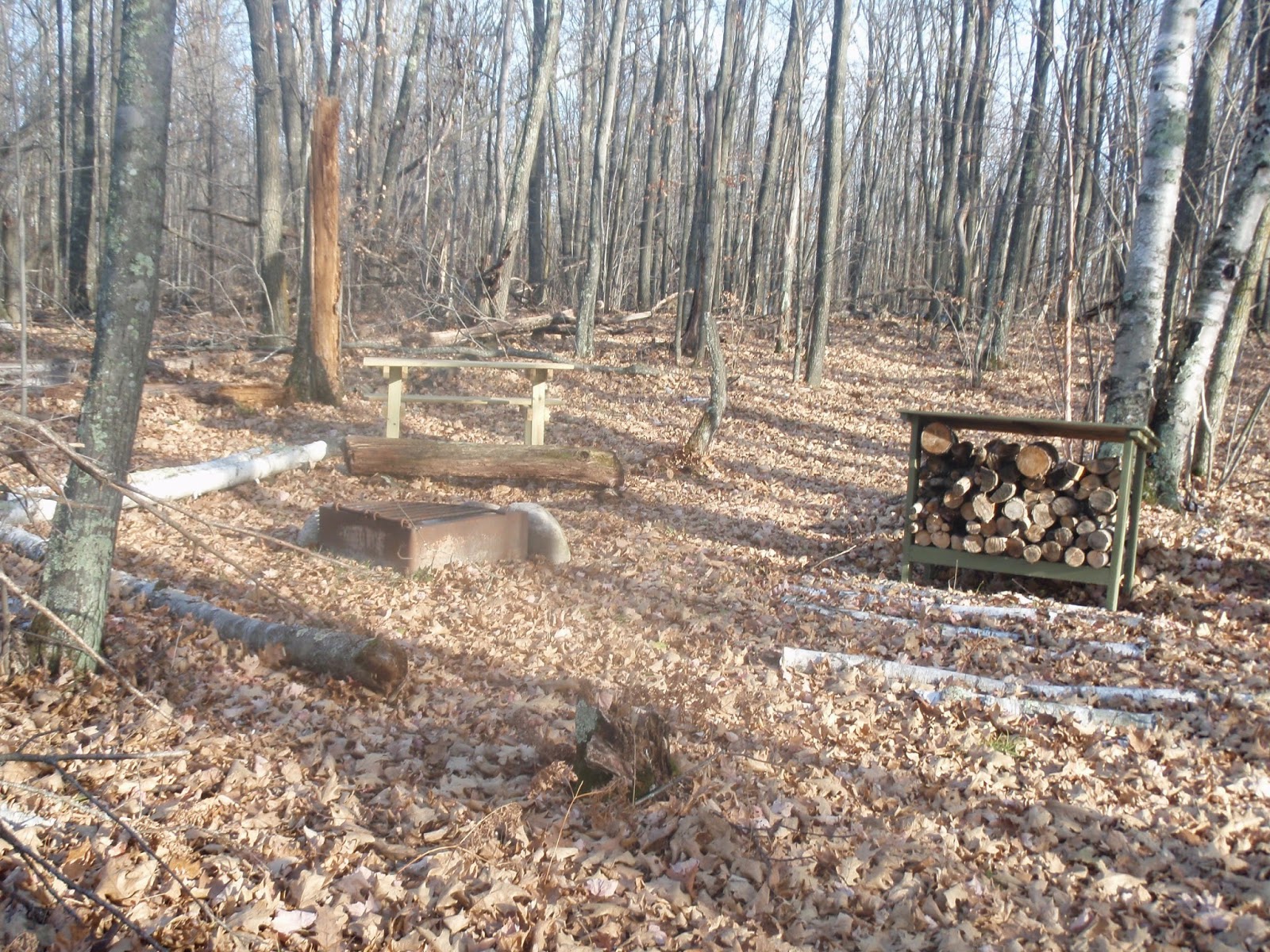
This is just a nice campsite on a nice little lake.  A few years back NCT volunteer Tom Moberg adopted this stretch of trail and started making some improvements to the campsite.  This campsite has some great amenities such as a picnic table, campfire grate and even a wood rack.  It’s less than a mile from Forest Road 2117, which previously was a railroad grade known as the Speakers Truck Trail.  If you hike east from the campsite you will find a marshy lake that is really good for watching wildlife.

Lake Waboose and a bench at the campsite

Lake Waboose Campsite (Paul Bunyan State Forest)
This campsite, deep in the heart of the Paul Bunyan State Forest, feels like you are on an island, but it’s just a peninsula.  There is water on three sides of the campsite giving it an island feel.  You can access this campsite a couple different ways.  First you can park at the Lake Waboose parking lot and boat launch which is on the Lake Waboose Access Road.  Or you can park at the Akeley Cutoff Road trailhead and hike west on the NCT to the trail junction.  You will see some fishing boats out on the lake, but most of the fishermen don’t even know there’s a campsite on the lake.


The Flooded Woods right next to the campsite
Flooded Woods Campsite (White Earth State Forest)
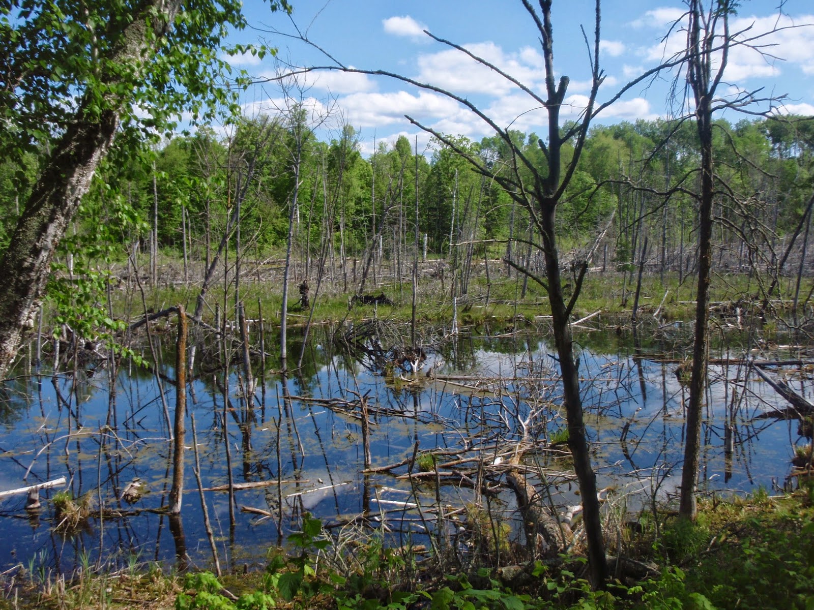
Oh yeah, talk about spooky, it’s the Flooded Woods.  This campsite is located on a very large Flooded Woods.  To get to the campsite, go to the Elbow Lake Road Trailhead and hike south.  Flooded woods always seem really creepy and murky, and this one is no exception. The campsite itself is really nice with grassy tent pads and a nice campfire area.


Cheesehead Bonus!!!!
Copper Falls State Park Backpacking Campsite.
Yes, since I’m from Wisconsin, I thought I would sneak in a Wisconsin Backcountry Campsite.  Well, here it is, the Copper Falls State Park Backpacking Campsite.  This is a fee campsite that can be reserved through the Wisconsin State Parks Reservation System  Basically, you hike along the Bad River Gorge seeing both Copper Falls and Brownstone Falls. Then you take the NCT back into the wood over a couple hills to the junction of the Backpacking Campsite Trail.  That trail is about .4 miles long and leads you down to the campsite near the fast cascading Bad River.  It’s a treat.  The handout for the Cheesehead Special is located here: https://docs.google.com/file/d/0B0O-3V5RfIrQUm0tSWt5YnJGbm8/edit

That’s all for now, so go out and enjoy a Summer’s Night at one of these campsites


Friday, February 21, 2014

The Coolest Backcountry Campsites on the North Country Trail in Minnesota, Part 1


As many of you know I created a presentation called “The Coolest Backcountry Campsites on the North Country Trail in Minnesota.”  I did an early version of the presentation at the Laurentian Lake Chapter’s National Trails Day Celebration in June 2012.  After that I presented a more refined version of it at the Midwest Mountaineering Outdoor Adventure Expo in November 2012 and again in April 2013. And lastly, I did the presentation at Fontana Sports Specialties in my hometown of Madison in May 2013.  I have been working on some new ideas for presentations, so it’s unlikely I’ll do the same “Coolest Campsites” presentation again.  But since I have the material prepared, including a great handout, why not cover the material again in the form of a blog entry?

And just like in the presentation, the first thing I’m going to tell you is why I like Backcountry Campsites. Backcountry Campsites have amenities like tent pads, latrines, and campfire areas. Plus, campsites are landmarks on a map, so you once you reach the campsite, you know how far you’ve hiked, etc.  Established backcountry campsites are better than dispersed camping. When you let people pick their own place to camp when they are dispersed camping, they could pick very bad places to camp. For instance, I have seen the remains of campfires at places that are far away from a water source.  In cases like that the campers may not completely put out their fire, leaving it to smolder.  This could cause a forest fire if the wind picks up and blows the ashes just a few feet. And, Backpackers are more likely to stop and camp at an established Backcountry Campsite instead of making camp at a spot where they are not supposed to camp.

There are around 155 backcountry campsites on the North Country Trail in Minnesota.  I have personally visited 135 of them.  All of the Backcountry Campsites are COOL, but what makes some backcountry campsites LESS cool than others. Here are some reasons why some campsites didn’t make the list. They are:
                        Too Sunny
                        Too Close to the Road
                        Too Bumpy or Sloped
                        Too Popular
                        No Water

All of those “Less Cool Factors” can be debated.  For instance, if you are out camping in the spring or fall, having a sunny campsite that will warm you up might be a good thing.  However, it’s not a good thing in the heat of the summer.  And if you’re hammock camping you really might not care if the campsite is to bumpy or sloped, as long as you have two trees to hang your hammock from.

So, what makes some Backcountry Campsites cooler than others? Well, I have a list of things I judge them on. Please note that my criteria for a cool campsite might be different than yours.
Here is the list:
                        Scenic Location
                        Near A Cool Landmark
                        Has Great Amenities
                        Has some Unique Quality you don’t see everyday

So, now for my list of the Coolest Backcountry Campsites on the North Country in Minnesota.  I am listing these campsite from east to west, so we start on the Superior Hiking Trail, then proceeding to the Kekekabic Trail, Border Route Trail which are all NCT affiliated trails, then we head to the NCT in North Central Minnesota.  You can follow along with my handout for this presentation, which has maps to each campsite and more detailed information. For the Handout: Click Here

 East Gooseberry Campsite Video

East Gooseberry Campsite (Superior Hiking Trail)
Start out at the Gooseberry Falls State Park Visitor Center and hike southbound on the Superior Hiking Trail.  It’s over 3 miles out to the campsite.  In that distance you will see the Gooseberry River change from a river full of rapids and waterfalls to a slow meandering river.  This campsite has the best view of the river compared to the other 3 other SHT campsites along the river.  Just seeing the changing features of the river makes the experience of visiting this campsite.


The Boardwalk going out to Lily's Island


South Sonju Lake Campsite (Superior Hiking Trail)
The Campsite isn’t all that cool by itself; in fact it doesn’t have a view of the lake.  But walk down the Superior Hiking Trail about 100 yards and you’ll find a boardwalk going out to Lilly’s Island.  It’s a great little island to have a picnic on or to just observe wildlife.  This little Island is one of the coolest spots on the SHT.


Falls of the Cross River Video

The Falls of the Cross River Campsite (Superior Hiking Trail)
As the name suggests, this campsite is near a waterfall.  This is a great waterfall that is not visited very often by tourists.  Instead the tourists head for Temperance River State Park, which is only about 4 miles away, where they can see many waterfalls.  So, hopefully, you’ll have this waterfall all to yourself to enjoy and explore.


Overlook of Oberg Lake on Oberg Mountain
Onion River Campsite (Superior Hiking Trail)
This is another case where the campsite itself isn’t all that spectacular, but it is near some very scenic landmarks on the Superior Hiking Trail.  If you hike less than a mile to the north you will get to Oberg Mountain, which has a 1.8-mile loop with 8 panoramic views to enjoy.  If you hike south on the SHT from the campsite, you will reach Leveau Mountain which has some panoramic views, too!


That's me exploring the Devil's Track River Gorge just downstream
of the two campsites.


Devil’s Track River Campsites
(Superior Hiking Trail)
There are two spectacular campsites along the Devil’s Track River Gorge.  How’d you like to camp next to a fast falling cascading river.  That’s what you can do at the very small East Devil’s Track River campsite. The river actually curves around the campsite as it descends towards Lake Superior.  A second campsite, the West Devil’s Track River Campsite is on a plateau above the River.  This is a much bigger campsite with several tent pads.  At either location you’ll be able to go out and explore the Devil’s Track River Gorge and Pincushion Mountain.


Hellacious Overlook, a great day hike from the Jackson Creek Pond Campsite
Jackson Creek Pond Campsite (Superior Hiking Trail)
Much like the Onion River Campsite, this campsite is between two high spots on the trail.  If you hike north on the Superior Hiking Trail from the Campsite in about 2 miles you’ll reach Rosebush Ridge, which is the highest elevation on the trail.  There isn’t a scenic overlook right at the “highest elevation” sign, but there are a couple good overlooks on the way up.  Heading south on the SHT from the Campsite you’ll reach Hellacious Overlook.  This is the first location where a hiker hiking south on the SHT from the northern terminus can see Lake Superior.  And this is a long overlook, too. It stretches over 200 yards along a ridge.

Stay Tuned for some more Cool Campsites when Part 2 is published.  It will feature campsites on the Border Route Trail, Kekekabic Trail and North Country Trail in North Central Minnesota.  Until then, make plans to visit one of the campsite I've already posted. If you have any questions on anything I've covered, please feel free to contact me at isawtman@gmail.com    For photos and trip reports of my hikes check out my hiking website: Click Here

Friday, January 24, 2014

10 unique places on the Ice Age Trail, so far


Back in December I finally decided to add up all the miles of the Ice Age Trail that I have hiked and it came up to 676 miles.  I have done three hikes since which solidly puts me over 700 miles completed.  So, it’s time to take a look back at some of the most unique and unusual places I’ve visited on the Ice Age Trail so far.  I have listed ten places that have caught my fancy and imagination.  They are listed in no particular order. I do admit that I am holding back a little bit.  I have some unusual places to spare, which I will use for another blog entry when I complete the next 400 miles.  So here we go

The World’s Only Pulp Wood Stacker in Cornell
According to its Historical Marker “The 175 foot tall Cornell Pulpwood Stacker remains as an impressive reminder of the great logging industry that dominates this part of Wisconsin.”  The stacker was built in 1912 and was used until 1972.   The stacker moved large quantities of logs used for papermaking from the Chippewa River and stacked them into large woodpiles.  The area around the Pulpwood stacker is now a park complete with a Visitors Center.  I remember seeing the Pulpwood Stacker off in the distance as I hiked south to Cornell along Hwy CC.
(In Photo: Myself, Will Luedtke and Jared Wildenradt)


Hartland Alley
Kevin Doxtater and I hiked along the parks and streets of Hartland about a week before Christmas in 2013. When we got to Hill Street, a main business district street, we had a hard time figuring out which way the IAT went.  It seems that Christmas Decorations on the street posts covered up the Ice Age Trail urban blazes.  But, after some looking around, I finally figured out where the IAT goes.  It goes down an Alley.  That’s right, it goes down a narrow alley between two businesses, then it crosses a creek into a park.  I’ve never seen a National Scenic Trail go down an alley before.


Sunburst Ski Area
There are many places on the Ice Age Trail where you can see people skiing.  The IAT roadwalk near Merrimac goes right next to Devil’s Head Ski Area, the roadwalk in Slinger goes next to Little Switzerland, and of course there is the Kettle Bowl where you walk along the base of the mountain.  But the Sunburst Ski Area near West Bend stands out beyond all the rest. Because at Sunburst, the IAT comes out right at the top of one of the Ski Runs and you actually walk next to the tow rope to descend the hill. This is an odd configuration for sure, but the people skiing seem to be used to it.


Monroe Grasslands
Heading North from Chicago Road near Coloma in the Mecan Springs Segment, you will soon find yourself in a huge grassland area.  This grassland once was part of a farm owned by Gordon and Joanne Monroe, who still live just east of the parcel.  It’s one of the biggest grassland areas that the IAT passes through and the rolling hills makes it even more impressive.  Walking through the middle of this big wide-open space just gives you a wonderful feeling.  It’s just as simple as that.  I talked with Gordon and Joanne Monroe and they seemed really happy that they sold part of their farm to the Ice Age Trail for everyone to enjoy. Full disclosure, Joanne Monroe is my mom’s cousin and I remember visiting the farm when I was a youngster.


The Bogus Swamp
If Bill and Ted were to have an excellent adventure in a swamp, it would have to be the Bogus Swamp near the town of Summit Lake.  That’s right, the swamp is not really a swamp.  It’s more of a patterned peatland, if you know what that is.  And, evidently it is extremely rare because there is just one other patterned peatland in Wisconsin. The Bogus Swamp is an 850-acre State Natural Area that hosts a variety of rare plants, butterflies and birds, so there’s nothing bogus about that, dude. (In Photo: Myself, Jared Wildenradt and Will Luedtke)


 Hillbilly Hilton
In the Langlade County Forest north of Antigo there is an old logging camp.  That’s not unusual, but this old logging camp has one remaining structure, a fieldstone basement building with a sod roof called the Hillybilly Hilton. This little dugout has two bed bunks that also serve as the seats for a table, a woodstove and a little kitchen area with pots and pans.  Evidently, from talking to Joe Jopek of the Langlade County Chapter, the Ice Age Trail has very little to do with the Hillbilly Hilton.  Sure, hikers and backpackers can stay overnight in the little dugout, but the building was fixed up by a couple of deer hunters who wanted a hunting shack.  (In Photo: Betty Schraith, Gloria Luedtke, Will Luedtke, Jared Wildenradt and Myself)


University of Wisconsin Golf Course.
A lot of people get their exercise by walking around at a Golf Course.  But this is a little different because the Ice Age Trail runs right through the University of Wisconsin Golf course.  The trail goes in the woods and grasslands between the fairways and at one point goes very near the Clubhouse, so you can stop by for some refreshments.  This is something I’ve never seen before, a National Scenic Trail designed into a golf course.  To me, hiking and golfing are very similar, except for in hiking you don’t have to chase after a little white ball.

Grandfather Falls and Dam
It’s kind of weird to list these two features together, but they are right next to each other, so that’s the reason.   North of Merrill, Wisconsin, Grandfather Falls is the largest falls on the Wisconsin River.  A truly scenic area where the Ice Age Trail visits on both sides of the Wisconsin River.  Grandfather Dam just north of the falls is an unusual dam because it uses huge wooden tubes called penstocks that the water shoots down through to turn the turbines.  This is one of the most powerful and efficient dams on the Wisconsin River. It’s so unusual to see a unique natural site and a unique man made site right next to each other. (In Photo: Jared Wildenradt)


Stone Elephant
South of Palmyra in the Southern Kettle Moraine State Forest lies a rock formation known as the Stone Elephant.  When you reach the side trail and see the rock you begin to wonder what the heck they are talking about.  It really doesn’t look that much like an elephant.  Then it hits you, it looks like an elephant’s face with a large elephant trunk.  I guess the rock is a little mislabeled. Instead of being called the Stone Elephant, it should be called the Stone Elephant’s Face.  In a way it kind of reminds me of Mooseface Rock on the Kekekabic Trail up in the Boundary Waters.  The Stone Elephant isn’t that big of a rock, I’d say about 5 feet tall.  So, you can easily climb up on top of it an get your picture taken conquering the Stone Elephant. (In Photo: Jared Wildenradt)


North of North Shuttuck Lake
Normally when someone talks about the Chippewa Moraine, they say what a great Visitor Center is located there.  The Chippewa Moraine, located northwest of Cornwell, is really well done.  Besides the great Visitor Center it has nice backcountry campsites and the Circle Trail that uses the Ice Age Trail as part of its loop.  There are many lakes in this area including the two biggest, South Shuttuck Lake and North Shuttuck Lake.  The Ice Age Trail goes along the shoreline of North Shuttuck Lake and also goes next to a lake north of it. That lake happens to be named North of North Shuttuck Lake.  It’s a nice enough lake without any overly outstanding features, but the name sets it apart. I get a kick out of the name  every time I see it. Fortunately, there isn’t a lake directly south of South Shuttuck Lake.

What unique places will make my next list? Find out when I finish the Trail

For More photos of my hikes go to Tman's Ice Age Trail Treks website at
http://sites.google.com/site/tmansiceagetrailtreks/

Saturday, November 9, 2013

Taylor and Lincoln Counties Backpacking Corridor


Just a little background on myself, I have done all of the non-roadwalk miles of the North Country Trail in Minnesota with the exception of 60 miles near Duluth.  That’s over 550 miles of trail including the NCT in Itasca State Park, Chippewa National Forest, and the Kekekabic, Border Route and most of the Superior Hiking Trail.  And recently I’ve been doing some substantial chunks of the IAT which also adds up to over 500 miles.

Last April and November I did a presentation called “The Coolest Campsites on the North Country Trail in Minnesota” at the Midwest Mountaineering Outdoor Adventure Expo in Minneapolis.  The handout for the class is posted on my website at http://sites.google.com/site/isawtman/   I have visited over 140 of the 150 backcountry campsites on the NCT in Minnesota, which gives me a unique perspective on campsites.

I believe the Ice Age Trail corridor in Lincoln and Taylor Counties in particular could become a very good backpacking area. Several improvements to the IAT in that area would help foster more backpacking. Let’s take a look at the Superior Hiking Trail, it is 315 miles long, minus 45 miles around Duluth, that leaves about 270 miles of backcountry hiking.  The SHT is a very popular hiking trail, perhaps the most popular in the Midwest.  It has 93 established backcountry campsites.  So doing the math, that’s one every three miles on average.  Plus add in 6 state park campgrounds, and city campgrounds in towns like Grand Marais and Two Harbors.  So I really think you need more established backcountry campsites in the Lincoln/Taylor corridor.

So, what are the components of a Backcountry Campsite?  Most Backcountry campsites have several components. They are: trail leading to the campsite from the main trail, tent pads, campfire area, trail leading to the latrine and the trail leading to the water source.  I’ve seen some campsites with additional amenities like picnic tables, wood racks and more.

Why established Backcountry Campsites are better than dispersed camping?  Well, as I wrote in the previous paragraph, Backcountry Campsites have amenities like tent pads, latrines, and a campfire area.  Plus when you let people build their own campsite when they are dispersed camping, they could pick very bad places to camp. For instance, I have seen the remains of campfires at places that are far away from a water source.  In cases like that the campers may not completely put out their fire, leaving it to smolder.  This could cause a forest fire if the wind picks up and blows the ashes just a few feet.

Plus, Backpackers are more likely to stop and camp at an established Backcountry Campsite instead of making camp at a spot where they are not supposed to camp. For instance, in June I encountered some backpackers camping on Alta Springs Fishery Land, which is off limits to camping.  If there was an established backcountry campsite in the nearby Lincoln County Forest, I’m sure they would have stopped at the campsite instead of camping someplace they are not supposed to be camping. Since the IAT has several locations where it is built in State Fisheries and Wildlife Areas which don’t allow camping, it’s important to build campsites on lands that do allow camping.

Why Backcountry Campsites are better than Campgrounds.  Well, when you are at a campground there could be plenty of people around.  When I hiked through the New Wood County Park campground in July, I noticed there was one campsite where there were over 100 spent fireworks. That might not be the ideal situation if you are looking for some peace and solitude.  Backcountry Campsites give you more of a wilderness experience where you can truly connect with nature.

The IAT has built a few waterless campsites like on the hill near the Merrimac Ferry and the most recently one near the Monroe Grasslands in the Mecan Springs Segment.  But, at both locations it says that campfires are not allowed.  Plus, the areas those two campsites are located in more rural areas, as opposed to more wilderness type areas in the Lincoln/Taylor Counties Corridor.

Why having the campsites about 3 miles apart is a good idea.  As mentioned in the earlier paragraph, the SHT has campsites on average about 3 miles apart.  This is not always the case. They do have an instance where campsites are 8 miles apart and several instances where campsites are clustered around a water source.  But having campsites around 3 miles apart is a good idea.  For instance, if I’m backpacking during the summer and I arrive at a campsite at 5 pm, I would most likely continue hiking to the next campsite if it is only 3 miles away.  If the next campsite is 7 miles away, I would probably stay at the campsite where I was at.  Thus, having more campsites gives backpackers more options.

There is a section of the Ice Age Trail in Taylor County that does have campsites at a very good rate. That section is in the Chequamegon National Forest starting at Lake Eleven.  In that area the IAT has campsites at Lake Eleven, Jerry Lake, and South Fork of the Yellow River. Continuing east there is supposed to be a campsite east of the Hemlock esker, but I was unable to find it with my backpacking party of 5.  Also, I had Jared and Will look for it on their hike and they were unable to locate it.  So, theoretically if there actually is a campsite there, that would continue the streak of campsites. Then there is a campsite at the southern junction of the Chippewa Lobe, and another one at the northern end of the Chippewa Lobe.  Hiking east from there you would get to the 4 campgrounds at the Mondeau Flowage after about 8 miles. 

So, it think the IAT needs to build off of that good stretch of campsites.  For Instance, the logical starting point for hiking is at the Trailhead near Hwy 64 near Lublin. But the nearest campsite to that location is Lake Eleven, which coincidently is 11 miles from the Hwy 64.  I think the IAT could use at least two campsites in the area between Hwy 64 and Lake Eleven.  One of the campsites should be within a mile of Hwy 64 and would be a Friday nighter campsites for people who come up on Friday night and want an easy campsite to hike in to.   I know that there is a need for campsites along that stretch of trail because I’ve seen several places where there are the remains of campfires.

So, at this point I think the logical place where the IAT should emphasize backpacking is starting at Hwy 64 near Lublin and going all the way to Grandfather Falls north of Merrill.   There are shorter roadwalks within that section, like the Fawn Ave roadwalk and the Harper Road/Rustic Road #1 Roadwalk, but I really don’t think those roadwalks will matter much to backpackers.  Meanwhile, west of Highway 64 is a 24 mile roadwalk to Cornell and East of Grandfather Falls is a 10 mile roadwalk to the Underdown.  So, I believe that the Hwy 64 to Grandfather Falls Section is the best spot to emphasize long distance backpacking.

It also should be noted that I have not hiked west of the Chippewa Moraine.  So potentially there could be a very good long distance backpacking area up that way. As far as other places that I’ve hiked being good backpacking routes, I’d say that the Chippewa Moraine is a great place for a weekend excursion.  It has three really good campsites along that section, and the IAT should add some more between the Chippewa Moraine and Cornell.  I also believe that the Underdown and Harrison Hills would also provide a good weekend backpacking trip.  Once you get east of the Harrison Hills near Parish, Wisconsin, the IAT goes on several two-track forest roads that ATV’s and Hunting Vehicles use, so it might not be all that appealing for backpackers.

People are looking for places for an extended backpacking trip.  I frequent the Forum on Backpacking Magazine’s website, and I’ve seen several posts from people who want to find a backpacking route within 5 hours of Chicago.  The Taylor/Lincoln area would fit the bill for those backpackers.  Plus the area is less than 3 hours from Minneapolis and St Paul.

The Taylor and Lincoln Counties Corridor of the IAT could become a very popular backpacking route.  It has some great features like the Hemlock Esker, Mondeau Esker and Grandfather Falls.  All the IAT would have to do is add some more campsites, emphasize the area as a backpacking area and it could really take off.  Having local volunteers provide a reasonably priced shuttling service would also help.

So, that’s just something for the Ice Age Trail people to think about as they are having their Regional Rallies over the next few weeks.